Tierra del Fuego and Cape Horn
Tierra del Fuego and Cape Horn
Tierra del Fuego and Cape Horn, is the land located in the southern tip of South America. Technically Tierra del Fuego [Spanish for Land of Fire] is the region south of the Straits of Magellan. The land directly south or adjacent to Strait of Magellan is known as the Big Island, which is part of the Tierra del Fuego archipelago formed by hundreds of lesser isles south to Cape Horn. The name seems to have been given by early explorers who nearly 500 years ago approached the coast of an unknown land for the first time. They observed dispersed fires and columns of smoke from the natives, which seemed to float upon the waters, in the mist of dawn. The “Tierra del Fuego” name is used in Argentina and Chile, since the islands are a shared territory.
Tierra del Fuego and Cape Horn
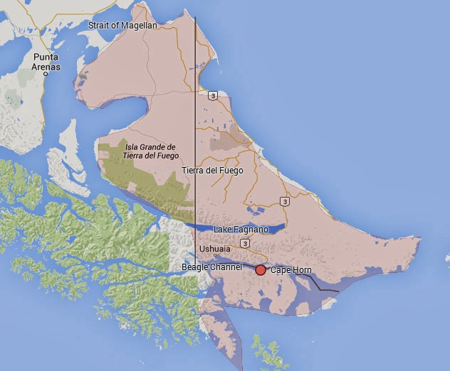
- Map of the southern most tip of South America showing Tierra del Fuego (shaded) and other landmarks.
Geography and Habitats on the Tierra del Fuego and Cape Horn Archipelago
The northern portion of the archipelago, mainly the Big Island, is composed of “pampas” (flat land) which are part of the Magellanic steppe. The infinite plains are dominated by grasslands interspersed by shrubs where sheep and cattle find the best conditions to graze. As you drive south the topography starts to get hilly and some patches of forest mixed with fresh water ponds, lakes and streams start to appear. This area, which constitute the middle portion of the Archipelago is called the Fuegian Park and combines both grasslands to the north and mountain woodlands to the south. The low deciduous beech tree (Nothofagus antarctica) is common and dominates the landscape flanking small valleys taken up by peat bogs. This is an area where guanacoes and foxes can be seen and beaver dams become more conspicuous, through their effect in the landscape. The great natural barrier between the north and the south of Tierra del Fuego is the magnificent Lake Fagnano, the largest body of fresh water in a wide valley eroded by glaciers.

- Guanacoes in Tierra del Fuego
Further south wider and deeper valleys lay the large Sphagnum peat lands and some of the hanging valleys still hold the remaining glaciers of the last glaciation, which covered most of these mountains and valleys some thousand years ago. Some mountains rise to 1,500 m a.s.l., and the treeline is easily identified at about 650 m a.s.l. The National Route Nº 3 crosses the Andes through the Garibaldi pass (about 450 m a.s.l.) and continues south, turns west and crosses the Tierra Mayor Natural Reserve and the Austral city of Ushuaia, meeting the coast of the Beagle Channel and finishing within the Tierra del Fuego National Park (Lapataia Bay).

Comments
Post a Comment